(Stillness in the Storm Editor) According to weather experts, hurricane Irma is one of the most powerful storms to hit the US in 10 years. It comes right after the wake of hurricane Harvey. Irma, in German, means war goddess. I’m not an expert in the morphology of hurricanes, but I did notice a clear set of radial striations that can be seen in the satellite imagery of Irma. These resemble striational patterning related to HAARP, as presented by Dane Wigington of Geoengineering Watch.
Here are the striations from Irma.
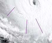 |
| Striations in hurricane Irma. |
And here are some alleged striations from a HAARP station, captured on satellite imagery.
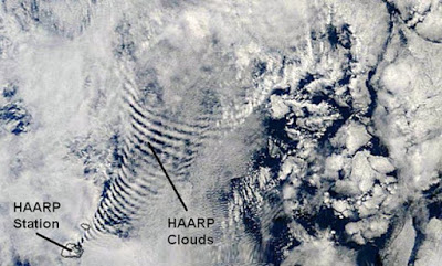 |
| Alleged HAARP striations |
I can’t confirm if these markings on Irma are proof of weather manipulation, but it would certainly fit the pattern with extreme weather events. Generally speaking, once weather manipulation begins, it has global effects, which also require mediation through geoengineering. In other words, if they stopped geoengineering completely there would likely be a major correction period of extreme and unpredictable weather. This means, that for all intents and purposes, all weather is “modified” to some degree, ever since the first geoengineering programs began.
There was also an X class solar flare earlier today. Furthermore, we’re also expected to receive the impact of a CME that occurred a few days ago. Both of these factors are likely to lead to a strengthening of Irma over the next 24 hours. Take care to prepare for any fallout and stay grounded emotionally.
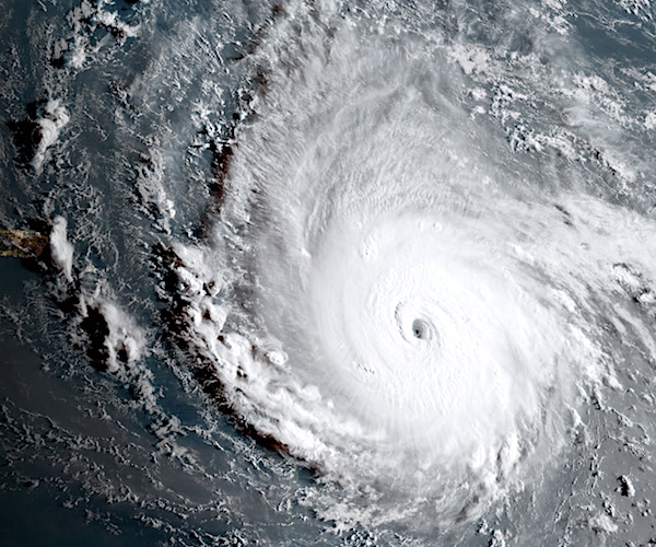
(Greg Richter) In this geocolor image captured by GOES-16 and released by the National Oceanic and Atmospheric Administration (NOAA), Hurricane Irma, a potentially catastrophic category 5 hurricane, moves westward, Tuesday morning, Sept. 5, 2017, in the Atlantic Ocean toward the Leeward Islands. This image was captured as daylight moves into the area, right, with nighttime features on the left side of the image. Hurricane Irma grew into a dangerous Category 5 storm, the most powerful seen in the Atlantic in over a decade, and roared toward islands in the northeast Caribbean Tuesday on a path that could eventually take it to the United States. (NOAA via AP)
Related Weaponized Weather? — Hurricane Harvey Hypotheses
Source – The Millennium Report
Hurricane Irma So Strong It’s Registering on Seismic Instruments
by Greg Richter, September 5th, 2017
Hurricane Irma, currently barrelling through the Caribbean toward Florida as a strong Category 5 storm, is showing up on instruments used to measure earthquakes.
“What we’re seeing in the seismogram are low-pitched hums that gradually become stronger as the hurricane gets closer to the seismometer on the island of Guadeloupe,” the U.K.’s University of Southampton seismologist Stephen Hicks told USA Today.
The hurricane is not causing earthquakes, Hicks said, but the high winds it produces, as well as the swaying of trees, transfer energy into the ground. Waves crashing against the shore also are a contributor.
Since the seismometer is near the ocean, that energy is picked up, Hicks said.
“Earthquakes occur 10s of (miles) deep inside Earth’s crust, a long way from the influence of weather events, and there is no evidence to suggest that hurricanes and storms directly cause earthquakes,” he added.
Strong storms often show up on seismic instruments.
“We saw this for Hurricane Harvey on seismometers located close to Houston,” Hicks said.
As Irma gets closer to the sensors, “we will see a dramatic increase in the amplitude of the seismic recordings,” he said.
_________________________
Stillness in the Storm Editor’s note: Did you find a spelling error or grammar mistake? Do you think this article needs a correction or update? Or do you just have some feedback? Send us an email at [email protected] with the error, headline and url. Thank you for reading.
Leave a Reply