
(Grant Ouellette) I add to the name game of Souss ‘Massa’: The state of Massachusetts was named after the Massachusetts Indian tribe that lived in the Great Blue Hill region near Massachusetts Bay. The word Massachusetts is an Algonquin Indian word which roughly translates to “large hill place” or “at the great hill.” The center of Atlantis could be considered the great hill.
Related Ancient Atlantis Research: Carmen Boulte (Video)
by Grant Ouellette, May 24th, 2020
And, in the name Nassau is ‘assa’ like in Massa, Bahama Momma.
According to the Reader’s Digest Illustrated Encyclopedic Dictionary (1987)
Atlantis (a) Legendary island in the Atlantic west of Gibraltar, said by Plato to have sunk beneath the sea.
Sahara. Perhaps both Richat and Souss Massa were cities of Atlantis, one or both being the capital. Both sights are uncannily similar to each other – possibly one built based on the other or both build based on the sunken capital. Did the Atlanteans have a template and technology to carve circular-ringed cities right into the hills, mountains and rock?
https://steemit.com/atlantis/@samstonehill/the-richat-structure-why-i-believe-this-is-atlantis
One theory tells of the creation of the Sahara Desert by the tsunami that wiped out Atlantis, but opinions vary.
I have read of a 7 bomb nuclear war on Earth involving Enki which created much of the Sahara Desert and other lasting effects like at Mohenjo Daro and the Dead Sea. Further, Mother Earth (Goddess Gaia) responded to the attacks on Her body such that earthquakes and tsunamis occurred. The dark entities and mankind lost vast amounts of information and technology at that time – much of it is still underwater – either Enki or his relative Enlil fled to the Andes in South America (Macchu Pichu?)
https://enkispeaks.com/how-nuclear-war-came-to-earth-3663-years-ago/
This website is one source describing evidence of a past nuclear explosion that created the Dead Sea.
In Scotland there are castles with (parts of) rock walls that have been turned to glass by heat events of unknown origin.
https://skeptoid.com/episodes/4326 (article entitled The Mystery of the Vitrified Forts)
So both the Richat Structure and Souss Massa might have been washed over by a tsunami and nuclear war – which could have altered some of Plato’s clues, for example the distance to the ocean.
Other sources mention a large island in the Atlantic Ocean, at some point(s) just a few miles from the African coast.
How was it obliterated?
Book The Emerald Tablets of Thoth-The-Atlantean
At the end of the 1968 movie Planet of the Apes the cabal informs us of past nuclear war on Earth:
Taylor, George = TG (Charlton Heston) gets off his horse: Oh my God. I’m back. I’m home. All the time it was … we finally really did it. You maniacs! You blew it up! TG utters some mild words as he looks upon the marred half-buried Statute of Liberty sticking out of the beach sand – New York nowhere in sight.
Was the Sleeping Prophet correct?
Edgar Cayce referred to Bimini (the closest point in the Bahamas to mainland USA) as one of the mountaintops of ancient Atlantis. While few would consider the island a mountain, 12,000-years ago it was one of the highest points on the vast land formation in the region.
https://www.edgarcayce.org/the-readings/ancient-mysteries/atlantis
The undersea Bimini Road is seemingly built out of cut limestone blocks and is unusually straight for half a mile.
https://allthatsinteresting.com/bimini-road
Are the undersea crystal pyramids near Bermuda part of Atlantis?
http://www.delightfulknowledge.com/giant-underwater-crystal-pyramid-discovered-in-bermuda-triangle
Another theory has Greenland as Atlantis. See the comparison of the shape of Atlantis in the 1669 map to that of Greenland
https://www.cryptidcampfire.com/cafe/athanasius-kirchers-map-of-atlantis
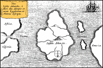
On observation, the only part of America that is shaped like that on the 1669 Atlantis map includes North Carolina sticking out. If so, then the map’s islands could be Bermuda and the Bahamas. To me, the shallow Sargasso Sea with its ocean gyre provides an excellent location for Atlantis, or part of it – and I lean toward Cayce being correct.
Through a rough analysis of Athanasius Kircher’s 1669 map I find no scale applicable to the whole map – the distances don’t make sense.
Assumptions:
The part of America sticking out the farthest is Nags Head, North Carolina; therefore true North is not directly to the bottom. The Strait of Gibraltar is the arrow head of the western end of the Mediterranean and it points roughly at Cuba or Hispaniola.
Using the distance from Nags Head to Tangier as 6,152 km or 3,823 miles gives my printed version of the map a scale of 880 km : 1 cm or 546 miles : 1 cm (my 12 inch ruler only has 30 cm of metric markings).
I follow through on this and the numbers don’t jive – I figure the map’s distance to America is a big guess, so I go back and recalculate a scale based on the distance from Bilboa, Spain to Tangier, Morocco which would have been better mapped in 1669. I get a different scale as follows:
Bilboa to Tangier is 869 km = 540 miles which is 1.5 cm on my map giving me a scale of 579 km : 1 cm or 360 miles : 1 cm
The closest point to Africa is 869 km or 540 miles.
I get the main island to be 3.5 cm x 4.5 cm or roughly equivalent to a 4 cm x 4 cm square.
Book The Children of The Law of One & The Lost Teachings of Atlantis
The main island area would then be 4 x 579 x 4 x 579 or about 5,363,000 square km = about 2,074,000 square miles.
In comparison, the world’s largest island today is Greenland at 2,166,000 square km; Australia is 7,692,000 square km, and the continental US (48 states) has an area of 8,080,464 square km = 3,119,884 square miles.
Let’s not forget reports telling how Lemuria existed from Hawaii all the way south to include hundreds of islands in the South Pacific.
There are many maps of Atlantis on the web.
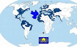
Given that Atlantis existed at the same time as Lemuria and both were advanced, empires around the world seems logical as purported in this map from Bing entitled The Atlantean Empire:
Other evidence to consider from Ancient Aliens Episode 5193 05-07-2019 Secrets of the Maya with Erich von Daniken – Spanish conquistadors obliterated the historic record of the Maya in the 16th century: in St. Augustine, Colombia the ancient Olmec people left giant stone heads with faces resembling people of 3 of the main Earthly dna groups including oriental and African. Further, the dna of some people in Colombia and Guatemala today traces to Vietnam, the Cham people and southern India.
Book The Lost History of Easter Island by Brian Foerster
Many other episodes provide worldwide phenomena and connections demonstrating proliferated pasts civilizations.
Another world connection is the similarities in the architecture of towers and minarets in India and Ireland.
From where did the tsunami(s) originate? Was there more than one tsunami? Are any of the Atlantic islands west of Gibraltar remnants of Atlantis; north to south: the Azores, Madeira Island, the Canary Islands or the Cape Verde Islands?
Maybe the volcano at the center of the 1669 map blew up like Thera did (Santorini 3,600 years ago).
What about the timing problem? For Atlantis to be at war with Athens as per Plato, both must have existed at the same time, but Atlantis sank in 9,800 BCE and the current reported origin of Athens is around 7,000 BCE.
Remember what John Lennon said when asked ‘How do you find America?’ Turn right at Atlantis.
Stillness in the Storm Editor: Why did we post this?
The news is important to all people because it is where we come to know new things about the world, which leads to the development of more life goals that lead to life wisdom. The news also serves as a social connection tool, as we tend to relate to those who know about and believe the things we do. With the power of an open truth-seeking mind in hand, the individual can grow wise and the collective can prosper.
– Justin
Not sure how to make sense of this? Want to learn how to discern like a pro? Read this essential guide to discernment, analysis of claims, and understanding the truth in a world of deception: 4 Key Steps of Discernment – Advanced Truth-Seeking Tools.
Stillness in the Storm Editor’s note: Did you find a spelling error or grammatical mistake? Send an email to [email protected], with the error and suggested correction, along with the headline and url. Do you think this article needs an update? Or do you just have some feedback? Send us an email at [email protected]. Thank you for reading.
Source:
https://operationdisclosure1.blogspot.com/2020/05/atlantis-richat-structure-and-other.html
Yo, the entire Targarian empire (Atlantis) was “mined” and processed between 1815 and 18??. This includes the Sahara desert to Mongolia. All the deserts in the current realm were created to root out the Targarians and wipe them off the earth, literally. Mud flood is the product of the dust created. Also the dust bowl in the midwest of the US. Petrified forest was nuked. Nuke blasts evident in the Sahara as well. We are awakening.