
(Matthew Cappucci) From a sizzling scorcher in the South to severe storms in the east and Mid-Atlantic, a ring of fire weather pattern will bring summer hazards to more than 40 million Americans for the first part of this week.
by Matthew Cappucci, August 13th, 2019
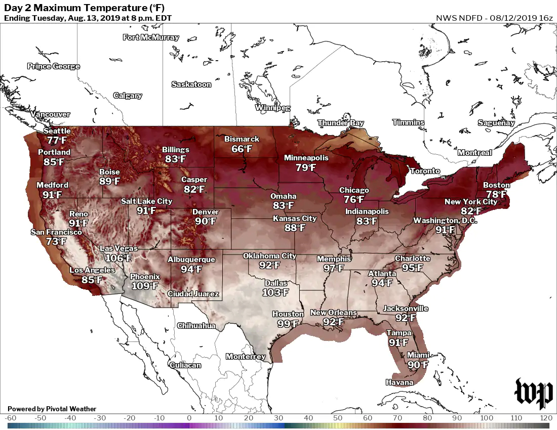
Heat alerts stretch more than 1,000 miles from San Angelo, Texas, to Jacksonville, Florida, a region where heat indexes could top 110 degrees Fahrenheit (43 degrees Celsius) in spots.
Areas that lie beneath a big, sprawling ridge of high pressure will bake, while clockwise winds around the high edges will slingshot periodic severe thunderstorms around its periphery. For those along the edge, it’s a one-two punch – a setup that begins for some with oppressive heat and humidity, and could end with damaging storms.
 High temperatures forecast for Tuesday. (The Washington Post)
The heat
Sauna weather is in the offing for people in more than a dozen states, the heat dome spanning from the I-35 corridor in Texas all the way to the East Coast.
In Dallas, the mercury is forecast to soar to 103 degrees F (39 degrees C) on Tuesday, the hottest temperature there since July of last year. Dallas/Fort Worth International Airport hit the century mark on Friday, Saturday and Sunday.
The average high for this time of year is about 96 degrees F (36 degrees C). In Galveston, the heat index remained above 100 degrees for an astonishing 41 hours late last week, the sultry conditions relentless even in the dead of night.
Orange, Texas, started its workweek on a not-so-pleasant note. The heat index had spiked to 111 degrees before 9 am, thanks to an extreme dew point of 83 degrees. The technical meteorological term for that is “yuck.”
Buy Book No Natural Weather: Introduction to Geoengineering 101
What sets this heat wave apart from others is the humidity, which is impeding people’s ability to cool themselves through sweating. The high dew points are partially traceable to Gulf of Mexico water temperatures running a couple of degrees above average basin-wide. (That is also something to watch for as we head deeper into hurricane season.)
The heat isn’t confined to the Gulf Coast, however. Oklahoma City hit 103 degrees on Saturday and 102 on Sunday. Will Rogers World Airport is set to top 100 degrees again Monday, marking the first three-day string of 100-degree days there since 2017.
There is a chance #Nashville could see their hottest day in over 7 years tomorrow
It'll all depend on how soon storms fire up in the afternoon pic.twitter.com/IavdmhnXHE
— Greg Diamond (@gdimeweather) August 12, 2019
If you’re looking to beat the heat, head north! Boston should enjoy a refreshing 76 degrees Tuesday, a welcome break on the heels of its warmest month on record. By Wednesday, an area of refreshing dew points in the upper 40s to near 50 degrees will filter south from Canada, bringing a comfortable early taste of fall air.
The storms
Where these two vastly different air masses clash, severe storms are in the forecast. Some meteorologists call them “ridge runners,” since they are propelled around the edge of the blocking high, such as the one parked over the South.
With plentiful heat and moisture to tap into, these storms could pack a punch, especially in the DC area on Tuesday. In these environments, storms sometimes have a tendency to be overachievers.
1:02am CDT #SPC Day2 Outlook Enhanced Risk: over a portion of the middle atlantic region https://t.co/rEAejNpVr0 pic.twitter.com/8Iyfx7Uvhg
— NWS Storm Prediction Center (@NWSSPC) August 12, 2019
The Storm Prediction Center has placed portions of the Mid-Atlantic, including Washington, Philadelphia and Baltimore, under an “enhanced risk” for severe weather Tuesday.
This category is not often issued for East Coast storm threats a full day in advance. It underscores the potential for Tuesday to feature a higher-end severe event for the Washington area. Damaging winds and hail are possible, but a few supercells with a low-end associated tornado risk may spin up along the warm front.
New Jersey is in the zone to watch as well. It has already seen eight tornadoes this year, highly unusual for a state whose annual average is two.
Buy Book Lights Out: A Cyberattack, A Nation Unprepared, Surviving the Aftermath
The flooding
On the northern side of the high, some flood risk is possible where storms may train over the same areas. A 24-hour rainfall total of 7.21 inches was recorded by a weather observer on the east side of St. Louis on Monday morning, while other amounts topping 4 inches were measured nearby.
A flash flood warning was issued for St. Louis early Monday, with more than three inches falling in just 90 minutes.
This entire strip mall parking lot is under water. This is off Nameoki in Granite City @ksdknews pic.twitter.com/MlgVtWZsv9
— Jenn Sullivan (@JennSullivanTV) August 12, 2019
The risk of flooding is forecast to wane as the system jaunts east, but it’s still something to watch – particularly Tuesday evening in New Jersey and spots just south of the New York City metro area, depending on how thunderstorm activity evolves. The Weather Prediction Center has included many of those areas under a slight risk of excessive rainfall.
2019 © The Washington Post
This article was originally published by The Washington Post.
Stillness in the Storm Editor: Why did we post this?
The preceding information is a news update. In general, staying informed as to events taking place is essential as an individual because it helps you navigate the world, and socially because you can gain and maintain rapport with your fellows. This rapport can be used to share information that can help others and improve the conditions of humanity in general. However, one must learn how to exercise discernment and proper critical thinking so they can make effective use of information gained.
– Justin
Not sure how to make sense of this? Want to learn how to discern like a pro? Read this essential guide to discernment, analysis of claims, and understanding the truth in a world of deception: 4 Key Steps of Discernment – Advanced Truth-Seeking Tools.
Stillness in the Storm Editor’s note: Did you find a spelling error or grammar mistake? Send an email to [email protected], with the error and suggested correction, along with the headline and url. Do you think this article needs an update? Or do you just have some feedback? Send us an email at [email protected]. Thank you for reading.
Source:
Is any of this extreme weather a result of geoengineering?
We need to SUE our governments for allowing these GeO Engineering Weather Modification via their poisoning the air column and destroying our protective layer of OZONE stopping the deadly UV C hitting us, which has never hit Earth before, and now Gates says due to their Chemtrailing for the last 20 years and very obvious trails spreading out to that flat dead grey cloud, These inhumans need to be exposed and sued out of existence, Its all part of their Agenda 21 to cause food shortages by crop failure and economic destruction of infrastructures via floods ,fires, high winds, ALL MANUFACTURED and nothing Natural ..
Heat Domes. caused by HAARP Microwave frequencies pushing up the stratosphere, help like that and causes all natural weather to be pushed out the way, , then lay a layer of Aluminum Barium Strontium to hold the heat IN, and there you are Humid massive heat wave, then turn the dome off, and in rushes cooler air into humid thick hot air and Massive Rainfall, Floods anyone, WOW another once in a hundred year storm of un matched rain fall, Really, the same as last month’s once in a hundred year storm ..
SUE these Zio freaks who want it all
What is ‘our government’? The one we have been taught all our lives that has our unalienable backs? The one we wore like a security blanket against the cold world? It’s been slashed and torn and no longer protects our backs.
So what do we do now?
We change.
Just like ‘our government’ did. We gather together and weave a new blanket, one that protects ‘we, the new people’.
We must change.